argus-atlas
argus-atlas 0.3.2.dev6+g77cc8fd @ 77cc8fdPyPI (opens in new tab)Source (opens in new tab)Changelog (opens in new tab)
Imported from README.md on argus-atlas's dev branch at that commit. Fixes go upstream, not here.
Bake one georeferenced fantasy-map overlay from real terrain.
argus-atlas warps a DEM into hillshade, slope, and land-mask control rasters with GDAL, restyles them through a diffusion backend with a cartography LoRA, stamps the painted pixels back onto the original geotransform, and cuts a PMTiles archive you can drape on a real map.
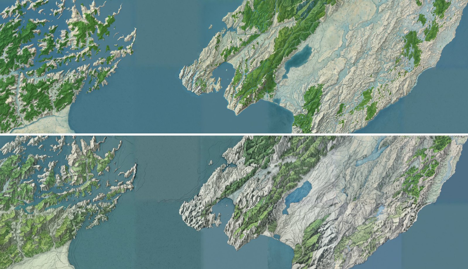
Cook Strait, New Zealand: the Marlborough Sounds on the left, Wellington and the Wairarapa on the right, as the Realms demo shows it. Each style is a block of 1024 px z10 chunks (argus-atlas chunks, 128 px seam margin, native zoom 12, 38 m/px) from Copernicus GLO-30 and OpenStreetMap layers, mosaicked into one tile set (argus-atlas mosaic). Juggernaut XL, no LoRA, 30 steps, cfg 6: preset antique at denoise 0.6 (top) and tolkien at 0.7 (bottom), seeds derived from each recipe and tile. Every chunk passed the alignment gate twice, once for its canvas and once for its crop, so coastlines run on across the seams and sit on the real ones when the layer is draped over a basemap.
Status: 0.x, pre-1.0: the CLI and job.json may still change between minor versions. Real AOIs pass the alignment gate, from single canvases (Lake Garda, October 2026) to blocks of seam-aware chunks (Cook Strait).
Docs: your first bake on a GPU host · styles and the knobs that matter · chunks, mosaics and place names · the alignment gate · relief and the z factor · data sources · CLI reference
Part of the Argus suite (opens in new tab).
Why this exists
Every piece of this pipeline already exists somewhere. No package puts them together, and none of them carries coordinates through the generative step. That gap is the product.
The nearest off-the-shelf neighbours and where they stop:
- Terrain analysis:
xdem(active) andrichdem(last release 2018) compute hillshade and slope as arrays. No 8-bit PNG export for a model, no sidecar, no canvas constraints. - Tiling:
rio-pmtiles(active, Protomaps) is the only maintained GeoTIFF-to-PMTiles route and is a candidate for thetilesextra. It has no alignment gate and no native-zoom ceiling. GDAL's own PMTiles driver is vector-only. - ComfyUI clients: none implement a placeholder contract where a missing placeholder is an error that names it, and none know what a hillshade is.
- Procedural generators:
worldenginerenders "ancient style" maps, but only from its own simulated worlds, never from a real DEM. - Research code:
generative-ai-mapmakingtrains an SD 1.5 ControlNet on Swisstopo vector tiles. Scripts only, no DEM input, no georeferencing after generation, seams left to the reader.
OSM layers and the composite
The hillshade tells the model where relief is, not where water, forest, towns or roads are. argus-atlas osm fetches those from OpenStreetMap for the same bbox, scale-aware (at zoom 11 you get motorways and primaries, not footpaths), and controls --layer burns each one to a mask on the canvas grid. The known layers are also painted over the hillshade into composite.png; the packaged comfyui_sdxl_img2img_composite_nolora template uses that as the img2img init image, so lakes come out blue and forests green while the ControlNet keeps the ridges where the DEM put them.
argus-atlas osm --bbox 10.55,45.40,10.95,45.90 --zoom 11 --layers water,rivers,roads,forest,urban --out osm/garda
argus-atlas controls --dem dem.tif --bbox 10.55,45.40,10.95,45.90 --out jobs/garda-2 \
  --layer water=osm/garda/water.geojson --layer rivers=osm/garda/rivers.geojson \
  --layer roads=osm/garda/roads.geojson --layer forest=osm/garda/forest.geojson --layer urban=osm/garda/urban.geojson
ATLAS_ALLOW_BAKE=1 argus-atlas bake jobs/garda-2 --checkpoint <ckpt> --workflow comfyui_sdxl_img2img_composite_nolora.json
Any OGR-readable file works as a layer, in any CRS; a name outside the palette is burnt as a mask only and is available to a template as $<name>. Where to get such files (HydroSHEDS, Natural Earth, Geofabrik extracts, GADM, land cover …) is in docs/data-sources.md. OSM data is ODbL; osm.json records the query and the data timestamp so the attribution can be traced.
Presets and provenance
argus-atlas presets lists seven named styles: six recommended (antique, imhof, tolkien, watercolor, minecraft, pixel) plus cyberpunk, kept but not recommended (see docs/styles.md). bake --preset <name> uses one; the API has GET /presets and takes preset on the bake request, so a demo can offer a fixed menu instead of free-text prompts. Every output carries the full request: the PNG in an EXIF ImageDescription and a text chunk, the GeoTIFF in TIFFTAG_IMAGEDESCRIPTION, the PMTiles archive in its metadata. exiftool fantasy.png, gdalinfo fantasy.tif or argus_atlas.metadata.read_png_payload() give it back, which is what makes a hundred bakes rankable later.
Chunks, mosaics and place names
A map larger than one canvas is baked one XYZ tile at a time. argus-atlas chunk --tile z/x/y --recipe <style> paints a tile plus a margin, with the chunks of the same recipe already baked around it pasted into the margin, so the model continues their coastlines and colours across the seam. The margin is then cut off and the crop is gated against the tile's own grid. argus-atlas chunks bakes a whole block in seam order from one DEM and OSM fetch, skips all-sea chunks and resumes where it stopped. argus-atlas mosaic combines a style's chunks into one tile set, with overview zooms for zooming out. A recipe (a JSON file such as examples/recipes/antique.json (opens in new tab)) pins the preset, checkpoint, LoRA, workflow and a per-tile seed, so re-baking a chunk gives the same image.
argus-atlas chunks --tile 10/1009/641 --rings 3 --recipe antique --out maps/antique \
  --sea-level 0 --allow-missing --land land.gpkg --labels --plan   # drop --plan to bake
argus-atlas mosaic maps/antique --out maps/antique.pmtiles
Place names never reach the model, which paints illegible lettering. argus-atlas labels writes them as a GeoJSON overlay from Natural Earth, a Geofabrik extract or the places layer of argus-atlas osm, ranked by zoom, and the viewer draws it on top in a real font.
docs/chunks-and-mosaic.md covers seams, tone matching, recipes, block fetches, resuming, the mosaic and labels in full. That is how the Realms demo was made.
Live demo
- Realms drapes the Cook Strait chunk mosaic above over an OpenFreeMap basemap, with a style switch and an opacity slider: slide it to see the painted coastline sit on the real one. What it needs live and how it is made: What to run for which UI.
- Argus Studio is the suite's web UI; its Atlas page is a thin shell over this package's API.
To run it yourself, examples/flow.html (opens in new tab) runs the whole flow against a local server (AOI, OSM layers, controls, bake, tiles, drape) and examples/viewer.html (opens in new tab) drapes any baked job on a MapLibre basemap with an opacity slider: start argus-atlas serve --cors (with ATLAS_CORS_ORIGINS='*') and open the page, or feed it a fantasy.pmtiles directly. The first real AOI (Lake Garda, Copernicus GLO-30, Juggernaut XL, no LoRA) passed the alignment gate on 17 Oct 2026; docs/your-first-bake.md has the commands for your own.
Quick start
GDAL is a system dependency, not a pip module. Install gdal-bin (Debian and Ubuntu), gdal (Fedora, Arch, Homebrew), or use the Docker image, which is built on ghcr.io/osgeo/gdal:ubuntu-small-3.11.4 and already contains GDAL 3.11 and gdal2tiles.py.
uv pip install "argus-atlas[cli,tiles]"
argus-atlas doctor
Healthy doctor output names a GDAL version, lists gdalwarp, gdaldem, gdal_rasterize, gdal_translate, gdalinfo and the tiler it found, reports whether ComfyUI is reachable and whether baking is allowed, and says whether the Go pmtiles CLI is on PATH (informational only; packing uses the Python library). If GDAL is missing it says so and exits non-zero. Paste this output into any issue you open.
Then run the no-GPU half of the pipeline on the bundled sample DEM (examples/sample_dem.tif, southern Lake Garda from Copernicus GLO-30, 577x577 cells, 350 KB; in the source checkout or the sdist, not the wheel):
argus-atlas controls \
  --dem examples/sample_dem.tif \
  --bbox 10.60,45.44,10.76,45.60 \
  --out ./jobs/sample

argus-atlas inspect ./jobs/sample       # sidecar: geotransform, canvas size, SHA256s, GDAL argv
For your own AOI, fetch the DEM first. argus-atlas dem finds the Copernicus GLO-30 tiles the bbox touches on the public AWS bucket (no login), reads only the needed windows of the COGs, and writes one GeoTIFF on their own pixel lattice, snapped inside the bbox:
argus-atlas dem --bbox 10.55,45.40,10.95,45.90 --out dem/garda.tif   # provenance in dem/garda.json
argus-atlas controls --dem dem/garda.tif --bbox 10.55,45.40,10.95,45.90 --out ./jobs/garda
A tile the bucket lacks is an error that names it. Copernicus leaves out all-ocean tiles, so for a coast pass --allow-missing to fill them with 0 m, the sea level GLO-30 uses elsewhere. --source (or ATLAS_DEM_SOURCE) points at a mirror URL or a local directory laid out as <key>/<key>.tif. The command prints the Copernicus attribution; keep it with anything you publish. controls may widen the canvas past the bbox to reach whole multiples of 64 px, and cells outside the DEM become NoData, so pass --cover when the edges matter: it snaps the window outward instead, so the GeoTIFF contains the whole bbox, still on the lattice. For a chunk, --tile z/x/y (with the same --size/--margin as chunk) fetches exactly that chunk's canvas, margin included, and implies --cover. An AOI touching more than 16 GLO-30 tiles is refused unless you raise --max-tiles. There is no server route for this: it is an open-ended download plus a GDAL job, and it belongs with the operator who builds a job.
Open jobs/sample/hillshade.png. If the relief looks right, the georeferencing is already fixed; the bake only changes pixel colours inside that frame.
Three ways to bake
Where it sits in the Argus suite
argus-quarry → argus-curator → argus-lens → argus-forge → trainer → argus-proof → argus-atlas
acquire          curate            caption      configs                  evaluate       bake
A cartography LoRA is trained with the existing suite and passed to atlas as a file. Atlas does not train, caption, or curate, and it does not modify the upstream packages.
Operator workflow
# Controls only (no GPU). Inspect the hillshade before spending a bake.
# --bbox is EPSG:4326 degrees. The --out directory name becomes the job id.
argus-atlas controls \
  --dem ./dem.tif \
  --bbox west,south,east,north \
  --out ./jobs/aoi-1

# Size the canvas either by its long side (default 1024, cap 1536, multiple
# of 64) or by an explicit ground resolution in metres per pixel. Too fine a
# resolution for the AOI fails and prints the largest --bbox that would fit.
argus-atlas controls --dem ./dem.tif --bbox west,south,east,north \
  --long-side 1536 --out ./jobs/aoi-1
argus-atlas controls --dem ./dem.tif --bbox west,south,east,north \
  --resolution 30 --out ./jobs/aoi-1

# Optional land mask, rasterised onto the same grid as the warped DEM.
argus-atlas controls \
  --dem ./dem.tif \
  --bbox west,south,east,north \
  --land ./land.gpkg \
  --out ./jobs/aoi-1

# Bake through a ComfyUI already running on the host GPU.
# Refuses with exit code 3 unless ATLAS_ALLOW_BAKE=1.
ATLAS_ALLOW_BAKE=1 argus-atlas bake ./jobs/aoi-1 \
  --checkpoint sd_xl_base_1.0.safetensors \
  --lora fantasy_map.safetensors --lora-weight 0.8

# Everything else has a default: --prompt, --negative, --seed (random if
# omitted), --steps 30, --cfg 6.0, --denoise 0.55, --models-dir, --workflow,
# --comfyui-url. Pass --out to bake a variant into a copy of the job dir
# and keep the original.
ATLAS_ALLOW_BAKE=1 argus-atlas bake ./jobs/aoi-1 -c sd_xl_base_1.0.safetensors \
  --lora fantasy_map.safetensors --seed 7 --denoise 0.6 --out ./jobs/aoi-1-d60

# Tiles are a separate step so a bad stylisation can be rejected before a
# pyramid is built. Takes the job dir or its fantasy.tif, re-runs the
# alignment gate, then cuts --min-zoom..--max-zoom (never above native).
argus-atlas tiles ./jobs/aoi-1 --out ./jobs/aoi-1/fantasy.pmtiles

# Print the sidecar: geotransform, canvas, hashes, GDAL argv, bake params.
argus-atlas inspect ./jobs/aoi-1

# Thin HTTP wrapper for argus-studio. --host defaults to 0.0.0.0;
# --allow-bake overrides ATLAS_ALLOW_BAKE for this process.
argus-atlas serve --host 127.0.0.1 --port 8105 --cors

# Report GDAL version, ComfyUI reachability, and whether baking is allowed.
argus-atlas doctor
Exit codes: 0 success, 1 runtime failure, 2 input error, 3 baking disabled.
What a job contains
jobs/aoi-1/
  job.json          # geotransform, CRS, canvas size, SHA256s, GDAL argv  ← coordinate authority
  dem_3857.tif      # DEM warped to EPSG:3857 and clipped to the AOI
  hillshade.tif     # gdaldem hillshade
  slope.tif         # gdaldem slope
  land_mask.tif     # gdal_rasterize of the optional polygon file (only with --land)
  hillshade.png     # 8-bit model inputs, no georeferencing of their own
  slope.png
  land.png          # only with --land
  fantasy.png       # raw model output, kept even if the gate fails
  fantasy.tif       # written only after the alignment gate passes
  fantasy.pmtiles   # zoom range native-2 .. native, bounded to the AOI
  labels.geojson    # place names for the viewer (only after `labels --job`), labels.json beside it
Defaults
ControlNet choice and weight live in the ComfyUI workflow template, not in Python. The packaged template is a starting point the operator replaces.
The ComfyUI workflow template
src/argus_atlas/templates/comfyui_sdxl_img2img_control.json is an API-format graph with $placeholders that bake fills: $checkpoint, $lora, $lora_weight, $positive, $negative, $seed, $steps, $cfg, $denoise, $width, $height, $hillshade, and optionally $slope and $land. Point ATLAS_WORKFLOW or --workflow at your own copy to change the sampler, the ControlNet, or anything else. Two rules:
- A placeholder the bake needs that is missing from the template is an error that names the placeholder.
- A template that contains
$lorarequires--lora.
The starter template names an SDXL depth ControlNet model directly; replace that name with whatever your ComfyUI has installed.
The alignment gate
Before a GeoTIFF or any tile is written, all of the following must hold:
gdalinfo -json fantasy.tifwidth and height equal the control canvas.- SRS is EPSG:3857.
- Corner coordinates match the sidecar within 1e-3 map units.
On failure the PNG is kept, no GeoTIFF is written, and the command exits non-zero. tiles runs the gate again, and a chunk is gated twice more: once with its seam blend and once as the cropped tile. See docs/alignment-gate.md.
When it fails
The three failures new users hit, and what to do:
HTTP API
Port 8105, a peer of the other suite servers. CORS from ATLAS_CORS_ORIGINS, default http://localhost:3000.
POST /controls takes dem and bbox ([w, s, e, n] or "w,s,e,n"), and optionally land, layers ({name: vector name under ATLAS_DEM_DIR}), sea_level, composite (default true), resampling, long_side or resolution, job_id, z_factor (default "auto") and vertical_exaggeration (default 1; see docs/relief.md).
Progress events on the bake stream, in order: controls, generate, georeference, then done or error.
Install
uv pip install argus-atlas                 # library only
uv pip install "argus-atlas[cli]"          # typer, rich
uv pip install "argus-atlas[server]"       # fastapi, uvicorn, argus-cortex[server]
uv pip install "argus-atlas[tiles]"        # Python pmtiles writer; the packer for the XYZ directory
uv pip install "argus-atlas[dev]"          # pytest, httpx, ruff
Python 3.11 or newer. MIT. GDAL (gdal-bin, including gdal2tiles.py) is a system dependency; argus-atlas doctor and GET /health report its version and fail clearly when it is missing. PMTiles packing uses the Python pmtiles library from the tiles extra, because the Go pmtiles CLI cannot pack an XYZ directory; the Docker image therefore does not ship the Go CLI.
Docker Compose
No GDAL on the host, or no sudo to install it? compose.yaml runs the CLI and the API from the image, with your paths and flags in .env:
cp .env.example .env          # set UID/GID (`id -u`, `id -g`) and the *_HOST paths
docker compose run --rm atlas doctor
docker compose run --rm atlas dem --bbox 10.60,45.44,10.76,45.60 --out /data/dem/garda.tif
docker compose run --rm atlas controls --dem /data/dem/garda.tif --bbox 10.60,45.44,10.76,45.60 --out /data/out/atlas/sample
docker compose up -d serve    # the API on 127.0.0.1:8105 (ATLAS_BIND, ATLAS_PORT)
docker compose build          # after pulling: `run` and `up` reuse an existing image
atlas is argus-atlas in a one-shot container, so any command works after it. Paths on its command line are container paths. The host directories in ATLAS_DEM_HOST, ATLAS_RECIPES_HOST, ATLAS_MODELS_HOST and ATLAS_JOBS_HOST (default ./data/{dem,models,jobs} and examples/recipes) are mounted at /data/dem, /data/recipes, /data/models and /data/out/atlas, and the bundled examples/ are in the working directory (/app, read-only to your uid, so write outputs under /data/..., not to relative paths). The container runs as your uid, so job files are yours, and reaches a ComfyUI on the host at host.docker.internal:8188. ComfyUI itself is not part of this file, and baking stays off until ATLAS_ALLOW_BAKE=1. argus-studio deploys atlas through its own compose; this one is for operators and development.
Develop
make install   # uv sync --locked: editable install from uv.lock with all extras
make test
make lint
docker compose --profile test run --rm test   # the suite against real GDAL, no host install
Versioning is derived from git tags via hatch-vcs.
Branches and releases. Work lands on dev (the default branch) through PRs, and main must never be ahead of dev, except by a release PR's merge commit (step 4). Branch from origin/dev and never push to main directly. Because main is protected, a release is a PR from dev into main:
- Cut the CHANGELOG on
dev: rename[Unreleased]to[X.Y.Zrc1] - <date>, then open thedev→mainPR. - Tag
vX.Y.Zrc1on the PR's head commit. That publishes a pre-release to PyPI, GHCR (:X.Y.Zrc1, never:latest) and GitHub Releases, so the exact commit under review can be installed and baked with. - Fixes go to
devand getrc2,rc3, …, each with its own CHANGELOG heading. - Once approved, rename the heading to
[X.Y.Z]and merge the PR. Its merge commit stays onmainalone, one commit ahead ofdevwith an identical tree: that is the one exception to the rule, so don't mergemainback intodev. Anything else onmainthatdevlacks is a mistake (git diff origin/dev origin/mainmust be empty). TagvX.Y.Zonmain. Only finals move:latestand the:X.Yimage tag.
If main stops requiring a PR, a release instead fast-forwards it to a dev commit that passed CI (git push origin origin/dev:main) and tags it there. That needs main to be an ancestor of dev, which a release merge commit prevents, so once one exists releases stay PRs.
main only changes through a PR with green CI. CI is a standalone workflow that apt-installs gdal-bin and python3-gdal before running the suite, since the tests drive real GDAL on a synthetic DEM. Release publishes to PyPI (OIDC trusted publishing) and GHCR on v* tags. This repo was scaffolded from argus-pkg-template (opens in new tab); run copier update to pull template changes.
Community and help
- Bugs and feature requests: GitHub issues (opens in new tab). Include your
argus-atlas doctoroutput and thejob.jsonof the failing job. - Show your bakes: open an issue with the AOI and a screenshot. Early users' AOIs become the gallery.
- Related projects: Protomaps PMTiles (opens in new tab) for the archive format, MapLibre (opens in new tab) for viewing it, ComfyUI (opens in new tab) for the generation backend.
Not in v0
- Downloading a DEM on the server.
argus-atlas demfetches Copernicus GLO-30 from the CLI; the API only names DEMs already underATLAS_DEM_DIR. - Training, captioning, or curating.
- A worldwide pyramid.
mosaicmerges the chunks of one style; nothing builds a global tile set. - Serving tiles beyond
GETof the finished PMTiles file. - GeoServer, PostGIS, tippecanoe, Leaflet, or any game logic.